
Page
Out
Records
Kerry
Links
| ||||
|
| ||||
| Home Page |
Starting Out | Online Records |
Research
Kerry |
Resource Links |
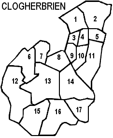
| Civil Parishes | ||||
Many thanks to Sean Ruad for the data in the IreAtlas Townland Database
|
Clogherbrien Civil Parish, Tralee PLU,
Trughanacmy Barony, Munster Province |
||
|---|---|---|
| Townland | Acres | Map # |
| Ballyenaghty | 190 | 17 |
| Ballynasare | 121 | 7 |
| Ballyroe | ? * | 8 |
| Bawnboy | 291 | 11 |
| Clashaphuca | 85 | 10 |
| Clogherbrien | 318 | 14 |
| Cloghmackirkeen | 251 | 2 |
| Gortnamuckaly | 66 | 4 |
| Kerries East | 309 | 16 |
| Kerries West | 268 | 15 |
| Knockaclogher | 51 | 3 |
| Knockanush East | 446 | 13 |
| Knockanush West | 489 | 12 |
| Knocknahaha | 169 | 1 |
| Parkboy | 81 | 9 |
| Pinure | 84 | 5 |
| Slievenavadoge | 185 | 6 |
*Ballyroe townland is in Clogherbrien according to the map information we have available, which is modeled after the Inner City Trust Maps (based on the Ordnance Survey 1846), but it is not located in the "General Alphabetical Index to the Townlands of Ireland" 1851 which gives us the data on acres. FYI "Ballyroe Br" (bridge?) is located on contemporary maps in the area our map here indicates.