
Page
Out
Records
Kerry
Links
|
||||
| Home Page |
Starting Out |
Online Records |
Research Kerry |
Resource Links |
| Civil Parishes | ||||
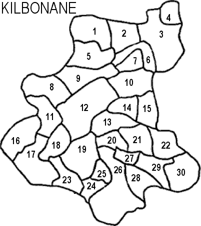
| Kilbonane, Magunihy Barony, Killarney PLU, Munster Province |
||
|---|---|---|
| Townland | Acres | Map # |
| Ahane | 187 | 28 |
| Ballymalis | 502 | 17 |
| Boulanimrish | 140 | 20 |
| Commons | 10 | * |
| Coolavorheen | 107 | * |
| Coolbane East | 12 | * |
| Coolbane West | 15 | * |
| Coolroe North | 256 | 11 |
| Coolroe South | 275 | 16 |
| Culleeny Beg | 116 | 25 |
| Culleeny More | 348 | 19 |
| Drombrick | 97 | 27 |
| Dromkerry | 342 | 30 |
| Faha East | 229 | 15 |
| Faha West | 187 | 14 |
| Gneeves | 131 | 24 |
| Kilbonane | 228 | 23 |
| Kilclogherane | 257 | 22 |
| Kilnarovanagh | 326 | 10 |
| Knockagowna | 210 | 13 |
| Knocknaman | 289 | 5 |
| Laharan | 287 | 2 |
| Lahard | 721 | 26 |
| Lisheennashingane | 324 | 1 |
| Lissavane East | 352 | 9 |
| Lissavane West | 410 | 8 |
| Listry | 717 | 12 |
| Rockfield East | 435 | 3 |
| Rockfield Middle | 315 | 6 |
| Rockfield West | 118 | 7 |
| Rosnacartan Beg | 170 | 29 |
| Rosnacartan More | 159 | 21 |
| Shrone | 148 | 4 |
| Slievegaura | 234 | 18 |
* indicates a townland in Kilbonane according to: *quot;General Alphabetical Index to the Townlands of Ireland" 1851, but is not on the map information we have available, which is modeled after the Inner City Trust Maps, based on the Ordnance Survey completed in 1846.