
Page
Out
Records
Kerry
Links
| ||||
|
| ||||
| Home Page |
Starting Out | Online Records |
Research
Kerry |
Resource Links |
| Civil Parishes | ||||
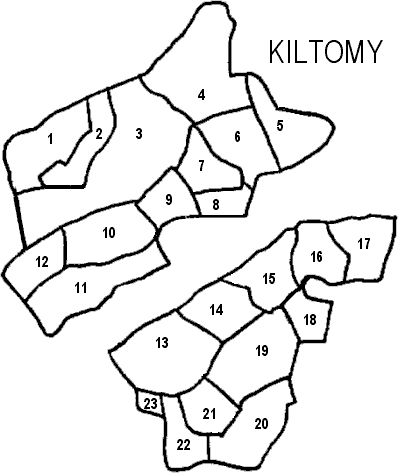
| Kiltomy Parish, Clanmaurice Barony, Listowel PLU |
||
|---|---|---|
| Townland | Acres | Map # |
| Aghabeg East | 704 | 3 |
| Aghabeg Middle | 337 | 2 |
| Aghabeg West | 319 | 1 |
| Aghacoora | 260 | 14 |
| Ballincloher | * | 11 |
| Ballincloher East | 291 | 10 |
| Ballincloher West | 175 | 12 |
| Ballincraheen | 215 | 17 |
| Ballinvoher | 148 | 9 |
| Clogher | 296 | 5 |
| Cloonsillagh | 69 | 18 |
| Coolaruane | 257 | 6 |
| Drommakee | 311 | 20 |
| Garrynagore | 361 | 19 |
| Gortaneare | 37 | 8 |
| Irrabeg | 269 | 16 |
| Killaspicktarvin | 386 | 13 |
| Kiltomy | 117 | 7 |
| LIXNAW T. | DNA | ** |
| Liscullane | 219 | 15 |
| Lissireen | 187 | 22 |
| Muckenagh | 611 | 4 |
| Parkmore | 43 | 23 |
| Tullacrimeen | 184 | 21 |
* Ballinclogher is on the Innertrust Townland list for this parish, but it is not included in "Aphabetical Index to the Townlands of Ireland" 1851, which is where the data for the acres of the townlands is located.
** DNA = Does Not Apply. Read why.