
Page
Out
Records
Kerry
Links
| ||||
| Home Page | Starting Out | Online Records | Research Kerry | Resource Links |
| "I purchased these old photos in Kerry recently, the date for all of them is unknown, but estimated to be 1880-1885." Thanks to Tony Riordan for the pictures and the commentary. Click on the thumbnail image to see a larger copy.
| |
 | This one shows the postal delivery wagon in Glenbeigh Civil Parish |
 | This shows a railroad train that ran between Tralee and Mallow,by way of Killarney until the early 1960's. The bridge still looks this way in 2000, though the train stopped running and the track is abandoned. The bridge is located in Kells townland, only a short walkfrom the farm of my great grandfather, John J. Riordan. This was partof the Mallow - Tralee line, the first Kerry rail line. It was built bythe Killarney Junction Line. The first part, from Mallow to Killarney,was opened in 1853, and the rest extended to Tralee in 1859. So, thisbridge was built before 1859. This would have been the train thatmost emigrants rode from this area, first to Mallow, where they switched toanother train enroute to Cobh Harbour, County Cork. This train also allowed many young farmers of this Caherciveen area towork farm labor jobs in the areas around Tralee. Caherciveen hasa milder spring than Tralee because of it's location near the warm watersof the Gulf Stream. farmers planted and harvested their crops earlier, andafter their own harvest was in, those ambitious or needy enough would takethe train to Tralee area to help in the harvest up there. At leastthat's what I'm told by some locals who should know... |
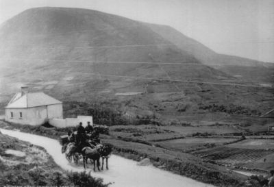 | This shows the National School in Kells. My grandfather walked toschool here. It looks just like this now. Note that the mail wagoncarried passengers, too! |
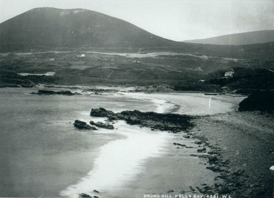 | This shows Kells Bay. The big house on the right with the smoke coming from one of the chimneys is called Kells House. Thelandlord here, Rowland Blennerhassett, built it as a hunting lodge. Eventually he moved there from Tralee area. My great grandfather's house is the white house closest to the left side of the photo. At least twogenerations of Riordans farmed the land from the house down to the bay,a total of 118 acres, held by two separate leases. The hill in thebackground is labeled "Drung Hill" but from my maps it appears to beMt. Foley. |
| Do you have non-copyrighted photos of Kerry that you think might interest other researchers? Email me: Waterlilys SHARE YOUR STUFF! |
Starting Out | Online Records | Research Kerry | Resource Links Home | What's New | Dingle | Site Map | Site Search |
If you've found this helpful, why not let us know by signing our guestbook?
![]() Waterlilys
Waterlilys