
Page
Out
Records
Kerry
Links
| ||||
|
| ||||
| Home Page |
Starting Out | Online Records |
Research
Kerry |
Resource Links |
| Civil Parishes | ||||
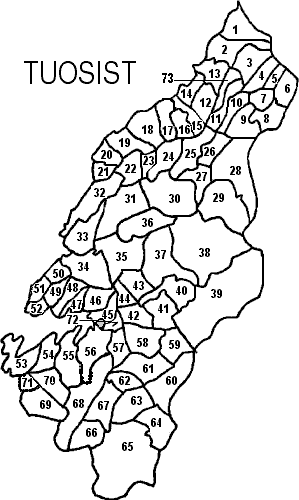
| Tuosist, Glanarought Barony, Kenmare PLU, Munster Province |
||
|---|---|---|
| Townlands | Acres | Map # |
| Ardea | 608 | 33 |
| Ballynafullia | 249 | 6 |
| Bird Island | 4 | ** |
| Canagullen | 555 | 63 |
| Canfee | 195 | 50 |
| Carks | 447 | 12 |
| Cashelkeelty | 595 | 55 |
| Clogherane | 699 | 61 |
| Cloonee | 700 | 32 |
| Collorus | 474 | 53 |
| Coolanaroo | 155 | 5 |
| Coolcreen | 739 | 60 |
| Coolownig | 165 | 71 |
| Coornacaragh | 326 | 26 |
| Coornagillagh | 213 | 21 |
| Cooryeen | 629 | 25 |
| Creeveen | 567 | 58 |
| Cuhig | 589 | 69 |
| Cummeen | 435 | 8 |
| Cummeengeera | 466 | 66 |
| Cummers East | 389 | 43 |
| Cummers West | 229 | 44 |
| Dawros | 415 | 13 |
| Deelis | 477 | 67 |
| Derreen | 282 | 45 |
| Derreenacallaha | 287 | 14 |
| Derreenatlooig | 208 | 47 |
| Derreengarrinshaugh | 203 | 73 |
| Derrinknow | 157 | 23 |
| Derryconnery | 401 | 46 |
| Derrygreenia | 472 | 70 |
| Derrylough | 855 | 31 |
| Derrynabrack | 390 | 22 |
| Derrynamucklagh | 453 | 24 |
| Derrynid | 231 | 20 |
| Derryrush | 230 | 49 |
| Derrysallagh | 483 | 9 |
| Derryvorahig | 277 | 10 |
| Dinish Island | 25 | ** |
| Dromaclaurig | 746 | 64 |
| Drombane | 229 | 7 |
| Drombohilly Lower | 814 | 36 |
| Drombohilly Upper | 777 | 35 |
| Dromdiraowen | 105 | * |
| Dromerkeen | 226 | 42 |
| Dromroe | 393 | 11 |
| Eskadawer | 371 | 54 |
| Fehanagh | 529 | 41 |
| Feoramore | 591 | 18 |
| Feorus East | 233 | 15 |
| Feorus West | 295 | 17 |
| Garranes | 944 | 37 |
| Glanmore | 2,245 | 65 |
| Glanrastel | 2,629 | 39 |
| Glantrasna | 2,105 | 38 |
| Gortavallig | 283 | 62 |
| Gortlicka | 459 | 3 |
| Inchicloon | 301 | 4 |
| Inchin Lough | 335 | 27 |
| Killaha East | 459 | 1 |
| Killaha West | 581 | 2 |
| Kilmakilloge | 342 | 48 |
| Knockowen | 449 | 59 |
| Lauragh Lower | 155 | 72 |
| Lauragh Upper | 383 | 57 |
| Lehid | 683 | 34 |
| Lohart | 482 | 19 |
| Loughaunacreen | 160 | 52 |
| Maulagowna | 1,061 | 28 |
| Muckera | 329 | 16 |
| Ormand's Island | 19 | ** |
| Reenkilla | 491 | 56 |
| Rossard | 947 | 29 |
| Shinnagh | 477 | 40 |
| Shronebirrane | 1,204 | 68 |
| Tragalee | 104 | 51 |
| Uragh | 1,086 | 30 |
* indicates a townland in Tuosist according to: *quot;General Alphabetical Index to the Townlands of Ireland" 1851, but is not on the map information we have available which are modeled after the Inner City Trust Maps, based on the Ordnance Survey completed in 1846.
** Island