History of
the River Barrow
 This river rises in the Slieve
Bloom mountains north west of the Ridge of Capard, in County Laois and
flows in a north easterly direction through mountainous forested land
crossing over the Slieve Bloom Way. After crossing the Slieve Bloom Way it
meets its first tributary, the Glenlahan River just upstream of Tinnahinch
Bridge,Co. Laois. from where it flows through agricultural land till it
turns in a south easterly direction at Ballyclare Brg. Downstream of
Mountmellick, which it by passes, it is joined by two other tributaries,
the Owenass that flows through Mountmellick and the Triogue that flows
through Portlaoise.
This river rises in the Slieve
Bloom mountains north west of the Ridge of Capard, in County Laois and
flows in a north easterly direction through mountainous forested land
crossing over the Slieve Bloom Way. After crossing the Slieve Bloom Way it
meets its first tributary, the Glenlahan River just upstream of Tinnahinch
Bridge,Co. Laois. from where it flows through agricultural land till it
turns in a south easterly direction at Ballyclare Brg. Downstream of
Mountmellick, which it by passes, it is joined by two other tributaries,
the Owenass that flows through Mountmellick and the Triogue that flows
through Portlaoise.
Onward it flows towards the sea this time in a
north easterly direction towards the town of Portarlington. This town is
the first major centre of population centre that it flows through. From
Portarlington the Barrow flows in an easterly direction toward the town of
Monasterevin where its receiving waters are swollen by the Fighile or
Black River. Fighile or Black River is a combination of the following
rivers - the Philipstown River which flows quite close to Dangan, Co.
Offaly and joins the Fighile at Clonbulloge, Co. Offaly. From there the
Fighile or Black River flows south towards Monasterevin and is joined on
the way by the Slate River which flows through Rathanagan, Co. Kildare,
and by the Cushina which does not have any major population centre in its
catchment. Before the Barrow leaves Monasterevin it has the distinction of
the Grand Canal (Barrow Line) passing over it via an Aquaduct.
(The above picture appeared for
sale on eBay recently c2008 Caption: The Slip, Kilkeeny Road, Carlow)
Should read Kilkenny Road!
The Barrow Navigation
- Carlow section of the Barrow Navigation
|
A Committee was appointed as far back as 1703
in the Irish House of Commons to propose a Bill to make the River Barrow
navigable. However, work did not actually start until 1761, and by 1800
ten lateral canals had been cut.
Lack of consistent depth in the river caused
problems, especially in summer, and commercial traffic was affected by
frequent delays. In 1935 the Upper Barrow drainage scheme resulted
in the lateral canals being affected by silting and finally commercial
trade was ended in 1959. The river is now navigable between Athy (County
Kildare) and St. Mullins (County Carlow). The Barrow Navigation is
linked with the Grand Canal via the Barrow Line, above Athy, and the Grand
Canal itself reaches west to the Shannon and east to Dublin.
The Barrow is Ireland's second largest river. It
runs for 192 km from source to sea and is navigable from
Athy to St. Mullins, some 68 km. There are 23 locks, including the sea
lock at St. Mullins. The Barrow Line of the Grand Canal is 46 km long and
forms the second part of the navigation carrying 9 locks between Lowtown
and the junction of the Barrow at Athy.
 Over 300 years before the Christian era, legend has it that a great
battle took place to capture the fort of Dinn Righ, a large mound near
Leighlinbridge. The presence of such formidable defensive structure
indicates the importance of the Barrow as a strategic military highway as
well as a highway for commerce since earliest times. Evidence of early
Christian and later medieval church establishments can be seen all along
the river, notably at or near St. Mullins, Old Leighlin, Carlow, Sleaty,
Nurney and Monasterevan.
Over 300 years before the Christian era, legend has it that a great
battle took place to capture the fort of Dinn Righ, a large mound near
Leighlinbridge. The presence of such formidable defensive structure
indicates the importance of the Barrow as a strategic military highway as
well as a highway for commerce since earliest times. Evidence of early
Christian and later medieval church establishments can be seen all along
the river, notably at or near St. Mullins, Old Leighlin, Carlow, Sleaty,
Nurney and Monasterevan.
The Barrow was a significant commercial
canalised waterway right up to the 1950's with important river ports at
Athy, Carlow, Graignamanagh and New Ross. Barges carried consignments of
malting barley to Dublin as raw material for the famous Guinness stout,
which was transported back downstream in its finished state. Later,
beet-filled barges supplied Ireland's first sugar factory at Carlow. The
Barrow is now completely given over to pleasure.
- Milestone at Knockbeg Lock
- Image was taken by Carloman2 in 2010
Barrow Wildlife
The unspoiled banks of the Barrow, the open fields and
woods, attract a huge variety of birds and waterfowl. Mallard and moorhen
can be seen fussing about in the quieter stretches. Kingfishers flit above
the water, while herons wait patiently for dinner to swim within striking
distance. Farmlands harbour lapwing, thrush, rook, hooded crow, pheasant
and woodpigeon. Other species commonly seen in Woodlands areas include the
little grebe, woodcock, the shy sparrow hawk, kestrel, whitethroat,
goldcrest, spotted flycatcher, long-tail tit, chiffchaff and many, many
more. The Barrow is a nature wonderland, providing many hours of enjoyment
for visitors cruising its waters. Electric blue and emerald green damsel
flies share the riverside flora with red admirals, painted ladies,
peacocks and common blue butterflies.
The Barrow River

Rathvinden Lock
Our exploration takes you downstream from Athy on a
journey of enchantment along the Barrow, a relatively undiscovered gem
among the great inland pleasure cruising waterways of Ireland. Here is a
river where the waters and backwaters soothe the soul and renew the
spirit. Ireland's second longest navigable river, the Barrow, is noted for
the beauty and variety of its landscape, the fascination of its historic
hinterland and the picturesque charm of its riverside towns. The marriage
of the River Barrow with the Barrow line of the Grand Canal takes place in
the Heritage Town of Athy. Great silos and malt houses surround the canal
harbour, where once warehouses were filled with grain and malt waiting to
be transported to Dublin by commercial barge.
Along the banks, adorned
with stately trees and cultivated fields, the empty eyes of old country
houses evoke a past where the pace of life was in tune with the waterway.
Fields of barley, wheat and beet accompany the journey under Maganey
Bridge. Below Maganey Lock, the River Greese enters the river, and
the River Lerr joins it at Shrule Castle. This dates back to
Elizabethan times and was later owned by Robert Hartpole, another Hellfire
Club member.
The soothing sound of falling water signals the approach of
another weir and the following lock. The Three Counties Pub at Maganey
reflects the fact that three county boundaries - Kildare, Carlow and Laois,
meet hereabouts. Tie-up, have a relaxing drink and enjoy the peace and the
company. Grangemellon Castle is on the east bank, once the home of
'Handsome Jack' St Leger, who was a member of the notorious Hellfire Club
and the founder of the St Leger race. Boats rejoin the river after
Levitstown Lock.
 Boaters take the Levitstown Cut to avoid one
of the river's un-navigable stretches. The longest of the lateral canals
on the river, it follows the main road from Athy to Carlow and is some two
miles long.
Boaters take the Levitstown Cut to avoid one
of the river's un-navigable stretches. The longest of the lateral canals
on the river, it follows the main road from Athy to Carlow and is some two
miles long.
After Bestfield Lock, the dominant feature is Ireland's largest sugar
refinery, which processes the raw material from the extensive beet fields
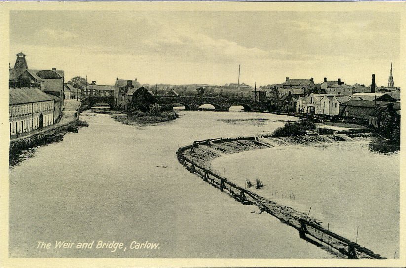
in the area. This signals the approach of Carlow Town. The boat stream,
which has been close to the east bank from Athy, now switches to the west
bank after Graiguecullen Bridge (1815) and its weir. Looming above the
bridge is the imposing ruin of the 13th century Anglo-Norman Carlow
Castle. The expanse of grassy quays and the huddle of warehouses bear
witness to the town's pivotal role in trade and commerce along the Barrow
Navigation. Below the lock is the fine modern marina of Ceatharlach
Moorings with overnight mooring facilities, toilets, showers, telephone,
safe docking, pump out and recharging facilities.
Below Carlow Weir, the banks are liberally endowed with walls of willow
sallies and alder. The landscape is according to Thackeray - the 19th
century satirist and author of Vanity Fair - "exceedingly beautiful, with
noble hills rising on either side and the broad silver Barrow flowing
through rich meadows of that astonishing verdure which is only to be seen
in this country". The pink heads of Himalayan balsam add an exotic touch
to the banks on the way to Clogrennan Lock.
Milford Lock is negotiated on the way to Milford, once the centre of an
extensive milling industry. It was from this quiet hamlet, that, in 1981,
Carlow became the first inland town in Ireland or Britain to receive a
public electric supply. The generating plant has been recently restored.
The idyllic setting includes 3 bridges, handsome mill buildings and a
wooded area, containing an aquatic triangle, rich with wildlife. The river
now meanders through tranquil countryside, past a wood of oak, ash and
draping willow, where time seems to stand still. An island-studded
straight stretch of water leads to Leighlinbridge. Glide through the
graceful arches of the oldest bridge on the river. The attractive 7-arch
structure was built in 1320 by Maurice Jakis and the castle which
dominates the river is known as the Black Castle, originally built in
1180.
The Barrow at Bagenalstown
 The sea of
tranquility may be on the moon, but the earthbound
version is the stretch of river between Leighlinbridge and Bagenalstown.
The celebrated Dinn Righ ring fort (not open to the public) on the west
bank presides over pastoral beauty and pastoral peace in equal measure
after which a cut leads to Rathellen Lock and on to Bagenalstown. The
approach to Bagenalstown is infused with the character of its 18th century
origins, with lovely stone-cut buildings, a drawbridge and a picturesque
lock. Cruise on through the east arch of a railway viaduct after which a
series of locks will keep the crew busy; these include locks at
Fenniscourt and Slyguff.
The sea of
tranquility may be on the moon, but the earthbound
version is the stretch of river between Leighlinbridge and Bagenalstown.
The celebrated Dinn Righ ring fort (not open to the public) on the west
bank presides over pastoral beauty and pastoral peace in equal measure
after which a cut leads to Rathellen Lock and on to Bagenalstown. The
approach to Bagenalstown is infused with the character of its 18th century
origins, with lovely stone-cut buildings, a drawbridge and a picturesque
lock. Cruise on through the east arch of a railway viaduct after which a
series of locks will keep the crew busy; these include locks at
Fenniscourt and Slyguff.
 The
restored lifting bridge, Bagenalstown
The
restored lifting bridge, Bagenalstown
Goresbridge, with its graceful 9-arch bridge, lies between Upper and
Lower Ballyellen locks. International buyers in search of high quality
Irish horses are attracted to the famous horse fairs held here every three
months. The presence of so many locks over a short 9 km of waterway,
signals a change in character to the landscape. The tension between the
valley and the surrounding hills increases and adds visual splendor to
the journey to Ballytiglea Bridge. Moor here for Borris (3 km). Borris is
the home of the Kavanaghs, an old Irish family and part of the MacMurrough
Kavanagh dynasty, former kings of Leinster. Beautiful stone-cut buildings
and traditional shop and pub fronts add to the appeal of the town. A
9-hole golf course and a linear park with picnic area and tennis courts
provide pleasant distractions. The pubs with their traditional music
sessions and friendly atmosphere have gained nation-wide recognition.
Below Borris Lock a miniature one-eyed bridge conceals a tiny harbour.
It was from this place that Arthur Kavanagh, who was born without limbs in
1831, set forth by boat to Westminster to fulfil his duties as Member of
Parliament. He was Lord Lieutenant of County Carlow, Member of the Privy
Council of Ireland, local magistrate and a superb horseman. Further
downstream, the Rhine-like aspect of the valley can be appreciated to the
full, with the Blackstairs Mountains on one side and Saddle Hill on the
other pinching the river tight between the valley walls. The hills flow
down to the river, retreat, and flow again, all clad in a huge variety of
deciduous trees, some of which bend their heads over the stream, creating
rich leafy banks of great beauty.
The broad graceful curves of the weirs and the setting of the locks at
Ballingrane, Clashganny and Ballykeenan provide beautiful subjects for
your camera and your holiday album. The river bends and bends again past
Silaire Woods and its choir of birds. This stretch of water is nature at
its most gentle, which makes the final bend all the more surprising and
exciting, when the colourful town of Gragnamangh is suddenly revealed on
the west bank, with Brandon Hill making a dramatic statement above it.
Graignamangh is in Co. Kilkenny, while Tinnahinch, on the east bank, is
in Co. Carlow. The beautiful bridge floodlit at night, links the two and
dates from 1767 when a canal system was being built on the Barrow to
improve navigation. Before the bridge and perched above the town is
historic Duiske Abbey, now beautifully restored. Norman monks from Stanley
Abbey, Wiltshire, founded it in 1204. Take time to walk through the town
with its great selection of shops, pubs and music. Those of you who like
long walks can take the road to Brandon Hill or head for Tinnahinch bridge
and join the South Leinster Way long-distance walking trail.
Cruising downstream, the valley becomes deeper, with first the west and
then the east banks carrying tiers of trees on steep hills which tumble
colourfully towards the river all the way to St. Mullins and the end of
the navigation.
St. Mullins is a scenically charming riverside village with an
impressive ecclesiastical history and is one of the most important
religious foundations in Co. Carlow. A walk of about 2 klm's from the
mooring leads to the graceful ruin of the monastery founded by St. Moling
in the 7th century. The kings of South Leinster, including the
MacMurrough-Kavanaghs, are buried in the precincts. A small bridle path
behind the ruins leads to St. Molling's Well, from which close up views of
the river, its weir and old millrace can be enjoyed.
Note from Carloman:
"Carlow Rivers"
- Ships could only come up as far as New
Ross, Co Wexford. You should be aware that the
Barrow is also not a
large river. The Slaney in Co Carlow is small in width and the
River Derry,
even smaller.
- The Irish Canals were not ship canals, but
were for horse drawn barges. The toe paths that the horses used make
ideal walks beside the rivers.
- What made the Barrow suitable for barges
was its conversion in places to a canal. This work was done before the
advent of railways which in fact in Britain and Ireland spelled the
death of the canals as the rails could go places where there were no
interconnecting waterways.
- The canals were build by men who were
called Navigators which became shortened to "Navvy". Up to the mid 1960
all manual labourers working on excavations were still called Navvies
and they are remembered in folk songs in Britain and Ireland.
- I recall as a child in the late 1950's,
Guinness barges bringing barrels of stout from Dublin down to towns like
Carlow.
- The Barrow was made usable by cutting
channels parallel to it and building weirs across the Natural river,
forcing a good flow of water into the side channels. Levels were taken
care of by lock gates. There are several sets of gates near Carlow and
just below the bridge there is a large weir.
Source: Carloman