Page
Out
Records
Kerry
Links
 | ||||
| Home Page | Starting Out | Online Records | Research Kerry | Resource Links |
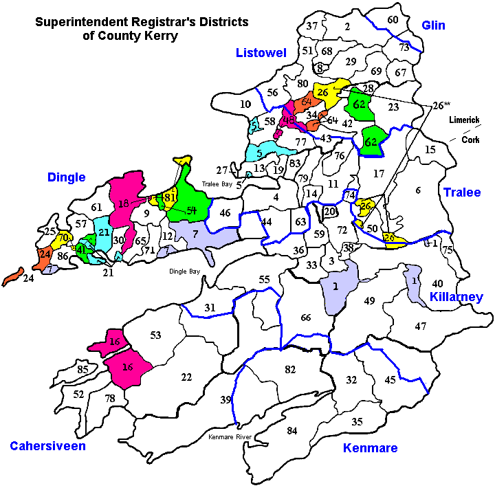
* Below is a map showing approximations of Superintendent Registrar's Districts of County Kerry including numbered Civil Parishes. Underneath the map is a list of all the corresponding Civil Parish names. Click on a Parish name from the list to go to a Townland map of that Parish.
In 1863 Poor Law Unions became known as Superintendent Registrar's Districts in order to record births, marriages, and deaths as a result of the 1863 Acts for the Registration of Births, Deaths, and Marriages, and the Dispensary Districts became known as Registrar's Districts. The PLUs of Kerry were: Cahersiveen, Dingle, Glin, Kenmare, Killarney, Listowel, Tralee. Registration Districts - In 1898, the Local Government Act adopted the Poor Law Unions as the basic administrative unit in place of the civil parishes or baronies. The unions were subdivided into 829 Registration Districts and 3751 District Electoral Divisions. Townlands were arranged according to these divisions, with parishes and baronies being retained only to make comparisons with records gathered before 1898. This is important to know to locate data for the 1901 and 1911 Ireland census information.
Thanks to John Willoughby for providing the information needed in creating this map for you.

| * Alternative Spellings (by no means complete) ** There are two seperate parishes named Dysert | |
| Ballyheige = Ballyheigh Caher = Cahir Castleisland = Castle Island Glanbehy = Glanbeigh, Glenbay | Kilcaskan = Kilcuskan Knocknane = Knockane Kilmalkedar = Kilmelkadar, Kilmalchedar Valencia = Valentia |